Sunday, December 20, 2009

Avalanche

Last week we saw our first major accumulation of snow. In some places there were reports of four feet! Not so much here, but a blue sky day and new snow that was just aching to be skied on. We climbed up into the basin, and noticed very few ski tracks and a few recent avalanche paths, including this one large slide.
The crown fracture line was just a few feet deep. You can see the major slide and then a smaller sympathetic slide right next door.
The debris crossed the valley, all the way to the small drainage.
A little over exposed (I don't know who left the setting at 1600ISO?) But this gives a better idea of the size of the event. We skied a little closer and then turned around and went someplace safer.

Tuesday, December 15, 2009

traveling meme

Well I haven't posted for quite some time due to some family traveling, with night time flying and events where it would be extremely bad form to photograph any surrounding outcrops.

Most of my field trips are close to home, the San Juan Mountains in SW Colorado and the red rock canyon country of Utah. I will also admit that most of the geology I do is done on the back of a mountain bike. My wife calls in recreation, but I am convinced we are doing real science.

This year, along with visiting my usual nearby haunts, there were three trips further afield. In April, my first trip to Hawaii! June saw us visiting Yosemite. Much of August and September was in New England helping family members.

Skiing near Red Mountain Pass last January
The black sands of Hawaii during spring break
Eye of the Whale arch in Arches National Park
Exploring Keg Spring Canyon and finding some great examples of late Paleozoic petrified logs.
Iconic Yosemite valley
Teaching a field class while floating the Colorado River.
Riding in Crested Butte. Great flowers among spectacular mountains.
The Colorado River flowing through an anticline.
As each year progresses, the to do list for the next year gets longer. 2010 is no exception. Hopefully there will be lots of time in the field, because as every geologist knows, life is a field trip.

Wednesday, November 18, 2009

Laccoliths as landmarks

A friend was asking about some interesting places to visit on the Colorado Plateau. I gave her some names of trails, canyons, drainages and ridge lines that I thought were fun. When it came time for directions I didn't use the typical cardinal directions, but instead used the location of the three main laccolithic mountain ranges of the Colorado Plateau. Needles to say...she gave me a hard time. Again, needless to say I gave her a little geology lesson concerning these mountain ranges.

In the late Paleogene-early Neogene, igneous rocks intruded into the area, "doming up" the overlying sedimentary rock creating laccoliths across the Colorado plateau. Over time, much of the overlying strata eroded away leaving the root of igneous rock surrounded by steeply dipping sedimentary rock. We just don't see much of a dip in sedimentary rocks in much of the plateau.

These small mountain ranges have captured some of the scarce water vapor that has crossed the arid Colorado Plateau creating many of the systems of canyons we see today.

These mountain ranges are also great landmarks as they can be seen from many parts of the eastern portion of the Plateau. It is comforting when you emerge from a canyon, look to the west and see the Henry Mountains. That and a GPS can get me to the car.

The Abajo Mountains west of Monticello.
The Henry Mountains. One of the last areas explored in the US.
Riding towards the La Sal Mountains. Right outside of Moab. These mountains are a beacon all across this portion of the plateau.
Looking south towards the Abajo mountains.

Wednesday, November 11, 2009

cause and effect

Here the Colorado River is cutting through an obvious anticline. The anticline was created when salt, deep underground, squished around and pushed sediment up.

What makes this image interesting is the potash plant. The right side of the picture shows the potash plant where they pump water down into the Paradox formation (salt from the Permian) The left side of the picture shows the vivid blue evaporation ponds. Water filled with paradox brine comes up to the surface evaporates away and leaves the salt behind.


Tuesday, November 10, 2009

misconceptions and difficult concepts


Last weekend we were riding bikes between the Anticline overlook, Canyonlands overlook and the Needles Overlook in the Canyon Rims National Recreation area.

Looking just above the Colorado River towards the Islands in the Sky, you can see a white strip creating a rather wide bench. The bench is named the White Rim and the rock unit is named after the bench. The sandstone is a brilliant white (hence the name) quartzose. In early Permian times, this region was a great inland sea of sand.

When I talk with teachers and students they almost universally understand that sediment was originally deposited horizontally. Most can at least intellectually understand the geologic time scale. What they don't seem to understand is that the rock unit does not exist in all places. Most of my students expect the White Rim, Wingate, Chinle etc to be found in all areas of the Colorado Plateau.

What seems to happen though in the translation from my field lecture (pointing, waving and talking) to their brains is that they believe that each rock unit is of equal depth for its entirety. It is only through much diagramming of sea level change and beach strands moving all over the state for me to get the bulb to light up. In this case, the White Rim's showcase is here on the Rim itself. As you travel north and east the rock unit itself thins out to nothing.

For a more in depth look at the geology of the White Rim sandstone visit Geotripper.


Wednesday, October 28, 2009

sharing earth science with the next generation

Thanks TC for the extension. Jess at Magma Cum Laude is hosting this month's Accretionary Wedge and has given us an extra week. Thanks!

This month is all about sharing our
love of geology with budding geologists. I get to work with K12 teachers every summer. We do a quick day on campus
(Colorado School of Mines) and then we take off for the canyons of the Colorado Plateau. Depending on the class we spend either 3 or 5 days on the river while studying geology. The teachers as students try their hand at calculating river discharge, suspended solids and total dissolved solids. We use inclinometers/Brunton compasses/ rulers-taped-to-protractors to determine the height of canyon walls. Once the height was calculated we determined the rate of incision using some local lava flows that have been dated. And sometimes we visit old Uranium mines. It is so cool to do such simple calculations that have real results. Oh-ya we also have a lot of fun doing geology outside!

I also spend some time with the kids themselves. Locally, Colorado History is taught in the 4th grade. We spend time wandering around old mining districts and trying to see what the old prospectors were looking for before they dug their hole. The kids love wandering around outside and looking at rocks!

Just last week I spent a day with some local 8th graders. We looked at geology with 2 views: identification and interpretation. We first identified the rock and then we interpreted what the rock could tell us about ancient times. We discussed rock units and mappable units. We examined sedimentary rock from an ancient ocean, igneous rocks that indicated a massive volcanic explosion and a metamorphic rock that showed us some impressive forces from Pre-Cambrian times. Again, you can't beat walking the mountains with a bunch of kids and just let the rocks tell their story.

Tuesday, September 29, 2009

Back in the Mountains- rock glaciers

My kids already know that I enjoy the finer things in life. The sun setting with palm trees in the foreground, fresh squeezed orange juice and rock glaciers. The San Juan mountains seem to have more than a few rock glaciers to observe and very few palm trees. These two examples are near Molas Pass on Highway 550. Hike south on the Colorado Trail and you will pass both within the first fifteen miles.

The basic ingredients to rock glaciers are pretty simple.
1. Lots of rocks! In both cases, the raw materials, talus, are made from the weathering of volcanic tuff. This volcanic rock is brittle and weathers easily into smaller chunks of rock. Mountains are great places for freeze-thaw weathering as almost every day of the year sees temperatures above and below 0 degrees C.

2. Frozen water. Within the pore space of these talus fields we find ice. Water has filtered between the rocks of the rock glacier and has frozen into place. Even though temperatures will rise above 0 C often, the insulating property of the rocks coupled with the lack of direct sunlight beneath the rocks keep the water frozen.

3. A slope. After even a small time hiking these mountains it is easy to see there is very little level ground. A slope is not hard to find.


Plenty of rock available. An obvious slope and we will assume some ice present under the surface layer of rock.
Notice the ribbing of rock. An ice glacier will exhibit similar crevasse fields from the movement of the mass.

Monday, August 31, 2009

serendipity and planning

Once again today I was transporting myself across the country...but this time by air. I had the opportunity to spend 4.5 hours in a small airport waiting for the small plane to be fixed. While waiting I met a man who worked in Antarctica during the IGY. ( I am being somewhat vague as we didn't discuss sharing his life story on the Internet)What a serendipitous meeting. We discussed life on the ice, science in the 1950's and how he used planning and homework to turn (even more) serendipitous meetings into a career. His interest in earth sciences dated back to a work study job as an undergrad. He started in his specialty because he needed one more class to fill scholarship scheduling requirements. He spent 5 years in Antarctica because he was the only one in his field that applied to go. I am not saying he lucked into his work, but that hard work and chance meetings enabled his career to take him to some amazing places. His stories were amazing and I would love to have him sit down in a high school science class and discuss field science in Antarctica in the 1950's.

It got me thinking about my circuitous path to my present position and how I can, maybe, help the next generation of scientists turn some serendipitous meetings into full time careers.

Friday, August 21, 2009

Only biology, but what a beautiful summer for wildflowers


I wish I knew all of the names. We had a fast snow melt but then a long cool wet summer. The rain coupled with a rich volcanic soil made the best wildflower season in years.


Near Crested Butter


Blue Columbine, the state flower


Elephant heads


Waterfall dropping through a thick layer of volcanic tuff


An incredible outcrop of conglomerate. As my wife said, every trip is a geology trip!


Sunday, August 16, 2009

Wheeler Geologic Area

The Wheeler Geologic Area is found within the La Garita Wilderness. Once named a national monument the area lost that designation but is now protected as a special geologic area within the wilderness area. The rock is a welded rhyolite tuff formed during the formation of the San Luis caldera, one of many explosive volcanic remains in the San Juan Mountains.

The geologic area is at the end of a 7 mile hike. The trail crosses some incredible meadows with views in all directions. I would not want to be caught in a lightning storm out there! The geologic area is eroding out of a hill side and shows all of the usual hoodoos, pinnacles and towers. It appears that the tuff in this area is not quite as welded as in other places giving rise to these great eroded remnants.


Crossing the meadows


The Wheeler Geologic Area in the distance


The hoodoos of Wheeler


Sunday, July 26, 2009

Educational unconformity

I find myself in New Hampshire right now because we received a phone call that had the words "dad, brain, surgery and cancer" all in the same sentence. Unfortunately air travel tickets were at a premium so we elected to drive. The drive while long was uneventful but it brought to mind a question poised by a student on my last field class.

How are continents made? Every earthscience teacher in the K12 world teaches about continents. They all explain to their students about how continents "float" while oceanic crust "sinks" They all explain how new oceanic crust is "created" at spreading centers, but none of the group I had ever discussed how continents are made.

A quick survey of my class found that no one really discussed this chapter of geology. I was wondering. Do university classes skip this? Do university students just forget this part? Or has this knowledge level eroded away?

Sunday, July 12, 2009

Out of context

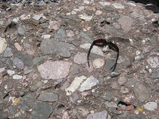
Callan talks about desk crop-samples. Here are two examples of "parking-lot-crop-samples".

How many times has someone come up to you as a geologist and asked you to identify a rock sample? How many times has the sample in question come from a nearby parking lot? This happens to K-12 teachers all of the time.

Many K-12 teachers are not geoscientists and I tell them that context will help them in trying to identifying the rock sample. They must ask the kids about the location that the rock came from. It helps the kids in creating the description of the
their rock sample as well as giving you an idea of what the name is .

I was particularly interested in how the crystalline sample was found next to the conglomerate sample. It is obvious that the they did not originate in the same place but both had been transported to this location. This can lead to a great discussion about how rocks can be moved: water, wind, truck.

Over the years, these parking lot samples have kept me on my toes, especially that one GEO 101 lab where the TA gave me some aged concrete to identify. I quickly learned that lesson.


Saturday, July 4, 2009

Why Geology?

In response to Magmalicious' question about why I ended up as a geo-scientist instead of perhaps a stock broker??

Neither of my parents nor anyone in my immediate family was interested in science...never mind the geo-sciences. It was in high school when I found that the landscapes I had been walking, climbing. biking and canoeing through had stories that could be teased out of the rock. It seemed that by following a few simple rules anyone could piece together this tale. I was hooked. What other field allowed me to be outside all the time and to do real science?

Studies in glaciology let me see why our backyard was full of cobbles from distant places and why the nearby lake was called a kettle pond and why Cape Cod is so rocky


Later, as an undergrad in Colorado, learning how seas had come and go through the years creating alternating layers of sandstone and shale out on the Eastern plains.

And then I found western Colorado with tertiary volcanics and sandstone canyons.

I decided to enter the world of the K-12 science teacher. In that time I figure that I have seen over 3000 students. I hope that I have shared this love of the outdoors, the story of landscape formation and how we can tease information out of the very rocks themselves.

Friday, July 3, 2009

Class time

One of the greatest classrooms I have ever had the opportunity to use has been the Colorado River. We spend 3 days camping and canoeing and doing geology for a teacher enhancement course. That means I teach teachers some simple geology and we all share ideas how we can bring kids into the world of rocks and rivers.

Looking down into the Grand Valley on day 1.


Canoeing past Entrada walls


Hiking into side canyons. Here the stream cuts into pre-Cambrian "Black Rocks" dated at 1.7 b.y. and is overlain by the Chinle formation aged approximately 0.2 b.y. Everyone thought that walking on 1.5 b.y of missing time was an impressive Saturday afternoon stroll.


getting ready


The arches of Mee Canyon. The erosive potential of the Wingate sandstone is seen here. The Kayenta caprock is missing and the windblown Wingate creates evenly placed joints that erode into columns. Our lab that day was to establish the height of the columns and then using the average local incision rate of 0.14 ft/1K years to calculate how long this canyon has been around...a fun time with math!


The crew

Friday, June 26, 2009

Summer vacation continued-Sierra Nevada

After leaving the Silver State we made our way to Yosemite. I had last visited as a 12 year old kid but I had some expectations after reading through geotripper's travelogues. I had read his posts and in the text books, I understood the batholith that is today the granite of Yosemite...but it was the brilliant white       of the rock that took my breath away.  The granite's that I have played on have not been as white as what I saw in Yosemite. The image on the left is the view of Yosemite valley that we saw. The white is not the granite, but a meteorological event called a storm. 


All the rain of the day before translated into some incredible waterfalls. Most of the water falls entering Yosemite valley are from hanging valleys, a byproduct of the last ice age. Here Nevada falls makes its way downward towards the ever popular and aptly named mist trail. The mist trail is in near Vernal falls and every hiker is "misted upon" making a favorite hike on a hot day.


The rocks along the roadside in King's Canyon showed a little bit of deformation here. From what I could find, this area was positioned immediately above the great batholith as a pendant of former rock. It was not quite melted but sure had some significant changes take place.


What visit to the Eastern Sierra would be complete without a visit to the Devil's Postpile. This classic... nay textbook example of columnar basalt was at the end of a short fun hike.


I remember when I read John McPhee's annals of a former world, he made a statement about needing a Californian to understand the geology of the Golden State. I am sure glad that there were a variety of guide books as well as geotripper's comments to help me along a great road trip.