Friday, September 24, 2010

AW 27 “What is the most important geological experience you’ve had?”

This month's Accretionary Wedge is all about important geological experiences. I am not sure if this is the most important or just one that hit my brain at the same time I took some pictures, but the theme has existed ever since I took Geology 101.

I entered the University of Colorado with geology on my mind. I never took anything beyond Earth Science as a freshman in high school and now I was in a real university with a geology department. From the first day I found that there was a story to be found in the rocks. By the end of the first semester, I could start to tease out those stories myself...as long as they were simple stories.

My important geological experience was that with some simple tools I could interpret a rock, a outcrop, a road cut and even a mountain range. This idea shook me up. Here is something that happened a long time ago and with a few rules of physics I could construct a story about the origins of a landform...I was hooked.

This week, I have been working on some landscaping in the backyard. Part of the plan needed some small river cobbles and even though I hate the idea of paying for rocks, it sure was easier to get a truck to dump 3000 pounds (1361 kg)in the driveway. While moving the rocks, I started looking at them ( surprised?) Since the gravel pit is on the Uncompaghre River I knew the source area and I picked out examples of the different rock units I have played in over the years. There was a cobble from the Ancestral Rockies caught in the Cutler formation, some Ouray Limestone and as I would expect lots of examples of the San Juan Tuff. I washed some up and placed them in chronological order. What a geo-geek. But then it was back to work and only a few pictures were taken.

I now take this show on the road and invite all kinds of kids to try their hand at telling the story in the rocks.


The headwaters of the Uncompaghre River near Red Mountain Pass

The 1361 kilogram pile in the driveway.
A small collection before I had to get back to work.

Wednesday, September 22, 2010

latent heat of vaporization

A non-geology topic for a second.

We have been canning peaches this past week and as I was waiting and waiting for the canner water to start boiling I was thinking of a quick blog post. Canning is the culinary analog for splitting firewood. Lots of work in the fall leads to fresh peaches in February. All together we have about 40 jars of peaches. That sounds like a jar a week until next summer!

yes it was night by the time we had put enough energy in the system to change states from liquid to a gas.
Working the peaches
Filling the jars

Check out how much energy it takes to boil water compared to other materials. At a point in my ancient history, I was an operator in a coal fired power plant. That is when I first learned that much of the coal we burned was to put water over the edge from a liquid to a gas. (chart taken from wikipedia)


SubstanceLatent Heat
Fusion
kJ/kg
Melting
Point
°C
Latent Heat
Vaporization
kJ/kg
Boiling
Point
°C
Alcohol, ethyl108−11485578.3
Ammonia339−751369−33.34
Carbon dioxide184−78574−57
Helium 21−268.93
Hydrogen(2)58−259455−253
Lead[3]24.5327.58711750
Nitrogen25.7−210200−196
Oxygen13.9−219213−183
R134a −101215.9−26.6
Toluene −93351110.6
Turpentine 293
Water33402260 (at 100oC)100


Wednesday, September 15, 2010

Peri-glacial evidence

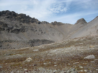
Last weekend we were hiking across the north facing slopes in a basin at about 13,000 feet when I saw these great examples of protalus ramparts. At one time there was a permanent snowfield above the piles of rock. Erosion happens (is that a band or a bumper sticker?) easily in the rotten San Juan Mountains of SW Colorado. The mountains fall apart easily with all of the freeze-thaw cycles that occur. The material falls with the help of gravity and rolls right down the snow bank coming to rest at the base of the snow. Now that the snow is gone we see hills of rough, angular debris that does not touch the "parent" slope.

Evidence of a colder time.


A straight on view.You can see that there is no cirque above the debris hill suggesting that this is not a moraine.
Another protalus rampart in the same vicinity. In this case, the oblique view allows you to see behind the debris hill.
Another example in the same basin and approximately the same aspect. No shortage of the raw material for talus.
Just had to add the picture of the lake.

Wednesday, September 8, 2010

Mesa Verde- geology and archeology

(after Wanek 1959 and Griffitts 1990)


A while ago we decided that we would spend the last of the summer explorations looking at the back country of Mesa Verde National Park. In the past few years, the park has allowed ranger led treks to look at some of the less explored regions of the park. It was one of these we decided to join.

Mesa Verde is made of basically four different formations, all of Cretaceous age. The Mancos shale forms the lower slopes and valley bottom. The Mancos is a marine shale and is ubiquitous in Western Colorado. Above the Mancos shale is the Mesa Verde Group composed of the Point Lookout sandstone, a beach front sandstone; the Menefee formation, a near sea-level marshy shale and the Cliffhouse sandstone, another shoreline sandstone. The regional dip is a shallow 2-3 degrees towards the south away from the La Plata mountains.


Many of the cliff dwelling are found in alcoves created where the permeable Cliffhouse sandstone meets the impermeable Menefee shales. The waters from rain and snow slowly percolated through the Cliffhouse sandstone until they reach an impermeable layer. The slight dip of the rock units channeled the moving water to the south creating many springs on the north facing slopes. These springs over time undercut the overlaying sandstone creating alcoves. The Anasazi (or Ancestral Puebloans) found these ready made alcoves complete with water sources a natural place to build some dwellings.

Looking up from the canyon bottom. The Menefee coal beds can be seen in the center. The cliffhouse sandstone at the top.
A large dwelling area built in an alcove created by water running through a horizontal crack. A large spring is just visible in the lower right at the bottom of the Cliffhouse sandstone.
While crossing a large expanse of sandstone we were treated to an amazing collection of hematite concretion shapes.
Another ruin showing how a spring created the alcove. The floors of the dwellings are built directly on the Menefee.
An alcove in the making right at the interface between the permeable Cliffhouse sandstone and the impermeable Menefee shales.