Tuesday, November 30, 2010

What I love about the geology of home AW 29

This month's question comes from Ann and her musings. She asks what about the geology of home do you love or perhaps not like. This was an easy one! Back in 2000 when the world seemed lighter and fresher and open to all manners of imagination, we moved ourselves from perfectly good jobs to the western part of Colorado just to be near the canyons and mountains. I won't go into how the education job market has been in a steady decline since 2001, but I will talk about the geology.

How can you not love the San Juan Mountains of Colorado? Just in a single glance we can see sediment deposited in ancient seaways and ancient deserts, intense mountain building with its accompanied faults and folds and the topped off with all sorts of volcanic evidence from lava flows and ash deposits to hydrothermal mineral deposits then the whole mix was well glaciated just a short time ago. My only compliant is that the area is so complex that my small mind has trouble wrapping around some of the views. I keep saying that the rocks tell a story, well this story is a bit complex.

The story doesn't end there. Just a short distance west is the Colorado Plateau. A fantastic playground full of red rock canyons, fast flowing desert rivers and evidence of previous occupants in the form of ruins and rock art. I have been so fortunate to spend the last 9 summers teaching K-12 teachers about geology while canoeing down some of the west's most iconic rivers, often in the footsteps (or paddle strokes) of John Wesley Powell. We explore pre-Cambrian rock units in some of the rapids we negotiate. We have a campsite on a 1.5 billion year unconformity. Students can observe the difference between sandstone deposited by water and sandstone deposited by wind. Then, at the end, we play particles ourselves and float towards the Pacific Ocean. What an awesome place.

A high country lake near Silverton Colorado
Red Mountain #2, taken from Red Mountain #1 on the edge of the Silverton caldera. Obviously a heavily mineralized area with not-so-original names.
An arch found in the Cedar Mesa formation
That's me on top of Bow Knot bend, named by Powell as the Green River flows 7 miles to travel 600 yards through a very tight entrenched meander.
Entering spilt mountain in Dinosaur NM on the Green River

Monday, November 29, 2010

metamorphism of snow

Last weekend we took advantage of a few days off and some new snow up high. One interest of mine has been watching the snow pack change over the course of the winter. This was more than an academic exercise during my search and rescue days since the character of the snow pack was a big indication of avalanche potential.

Right now the snotel site indicates we are a little shallow in snow depth for this time of year. The crystals (yes I know I didn't even think of taking a picture) are all small and are fairly evenly sized through the snow piles. The only different sized crystals were found at the surface where a thin layer of surface hoar is forming.

What we will look for now is to see if the cold night time temperatures will continue creating new crystals that will influence how cohesive the snow will act. The fun part...I will have to keep skiing and snowshoeing through out the winter. I hope to have periodic updates as time goes on, so stay tuned.

Making first tracks through a meadow.
Climbing towards a mine dump-avalanche chute. It is just the right angle for a slide
Winter has come back to the Colorado Rockies

Monday, November 15, 2010

Moab, Rivers and Geology

Last weekend found me back in Moab...go figure. This time I was attending the Moab River Rendezvous a get together created by Plateau Restoration, a group dedicated to protecting and restoring native habitats on the Colorado Plateau. The rendezvous was a chance for lovers of the plateau and its rivers to get together and learn more about the place, do a service project, see some phenomenal movies and have a blast while doing it.

I could not get away for the whole event, but Saturday afternoon and Sunday were lots of fun. Saturday afternoon, the keynote speaker Wayne Ranney discussed his newest book on Carving the Grand Canyon. The river runners in the room were held spellbound by his description of what lava falls would have looked like in the beginning. Later that night were some old home movies, taken by Grand Canyon river runners in some of the high water years in the 1950's before any dams were in place...it was a different world.

Saturday's field trip into Arches National Park was the highlight for me. We walked out Bloody Mary wash to fossil falls which is on the Moab fault. Slickensides and fossils on the same stop! We then drove into the park and spent most of our time looking at the salt valleys (collapsed anticlines) that were so instrumental in making the modern landscape we see today. There was lots of discussion looking at the orientation of the salt valleys and their relationship to the nearby laccolith mountains, the La Sals.


The Moab fault up close. This is called fossil falls as the (Honaker Trail, Pennsylvanian period) limestone on the left is just chock full of crinoid parts, horn coral and brachiopods.
Looking across the Colorado River towards the La Sal Mountains a 25 million year old igneous intrusion.
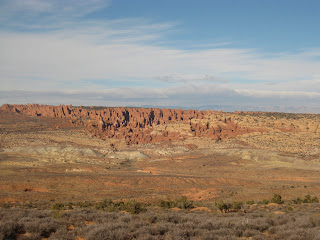
Looking across the salt valley into the fiery furnace. The salt valley is a collapsed anticline created by the movement of subterranean salt. The furnace is a maze of Entrada sandstone fins.
Not the best picture, but one of Utah's state emblems, Delicate Arch can be seen in the center of the image by its distinctive shadow. This view is also across the Salt valley collapsed anticline